To Create and Define a User Coordinate System Library
- Copy the file C:\Program Files\Bentley\Map CONNECT Edition\OpenCitiesMap\coordinate\seed\seed.dty to your_location\your_file .
-
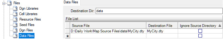
If preferred, place your DTY file in a sub-folder of your project
Base Source Directory. In the Geospatial Administrator, update the Files node
to include the DTY file.
-
Define MS_GEOCOORDINATE_USERLIBRARIES to point to
your_location\your_file. Use the form "Library[Name]" where Library
specifies the filename and the [Name] is the name of the root node for that
library in the user interface. Multiple libraries can be specified by
separating with a semi-colon. You can use a full file specification. If a
directory is not specified, MS_GEOCOORDINATE_DATA is used.
Examples:
MS_GEOCOORDINATE_USERLIBRARIES = d:\data\ProjectABC.dty[Project ABC]
MS_GEOCOORDINATE_USERLIBRARIES = d:\data\ProjectABC.dty[Project ABC];d:\data\ProjectXYZ.dty[Project XYZ]
MS_GEOCOORDINATE_USERLIBRARIES = $(MS_GEOWSHOME)\data\ProjectABC[Project ABC]
- If preferred, you can define this variable in the MACROS node of your user workset in the Geospatial Administrator.
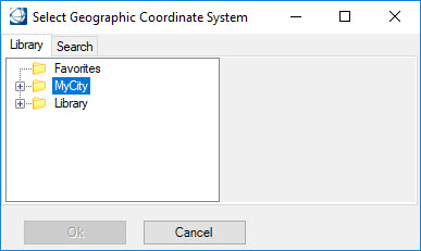
- After starting OpenCities Map, select .
- From the Geographic Coordinate System tool palette, select From Library.
-
Your user library will be displayed in the Library tab of the
Select Geographic Coordinate System dialog.